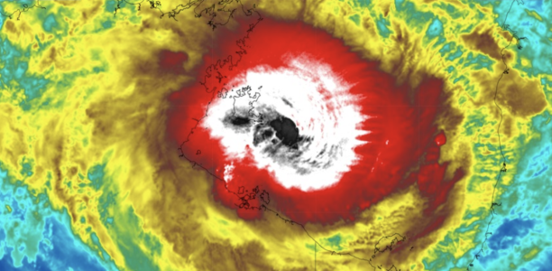
‘Destructive’ Tropical Cyclone Megan to make NT landfall
By
Seia Ibanez
- Replies 10
As Australia braces itself for the formidable force of nature, residents in the Northern Territory and Queensland are on high alert.
Tropical Cyclone Megan, a category three storm, is on a collision course with Australia's coastline, with an expected landfall near Borroloola in the Northern Territory (NT) on Monday evening, 18 March.
The cyclone, which took shape on Saturday afternoon, 16 March, in the Gulf of Carpentaria, has already unleashed a deluge on Groote Eylandt, dropping half a year's worth of rain.
The island was inundated with 431mm of rain in the 24 hours leading up to 9 am on Sunday, 17 March, following a substantial 249mm the day before.
The cyclone’s wind gusts reached up to 110km/hr. However, its wind speeds at its 'very destructive core reach speeds of up to 200km/hr, as reported by the Bureau of Meteorology (BOM).
The south-western coast of the Gulf of Carpentaria is particularly vulnerable, with destructive gusts exceeding 125km/hr expected to ravage the area between Nathan River in the NT and the Queensland border.
Adding to the cyclone's threat, the BOM has forecast 'abnormally' high tides.
The impending storm has prompted urgent warnings for residents in the northern parts of the Top End.
Authorities are urging the community to either make immediate preparations for the cyclone's arrival or evacuate the area to ensure their safety.
Weatherzone has highlighted the Carpentaria region of the NT as the likely to expect the heaviest rainfall, with Megan's western and northern flanks predicted to carry the most rain.
‘Widespread falls of 100-200mm are expected, with isolated falls of 300-500mm expected over the mainland in addition to the rain already fallen,’ Weatherzone reported.
As Megan moves inland, it is expected to weaken.
Queensland was also affected by the onslaught of Tropical Cyclone Kirrily in January, which was said to be one of the most powerful weather systems to have hit the north in recent memory.
The cyclone left thousands of homes without power and damaged infrastructure.

Remember, your safety is the utmost priority, and no measure is too small to protect yourself from the wrath of nature.
How do you prepare for an upcoming storm? Share them with us in the comments below.
Tropical Cyclone Megan, a category three storm, is on a collision course with Australia's coastline, with an expected landfall near Borroloola in the Northern Territory (NT) on Monday evening, 18 March.
The cyclone, which took shape on Saturday afternoon, 16 March, in the Gulf of Carpentaria, has already unleashed a deluge on Groote Eylandt, dropping half a year's worth of rain.
The island was inundated with 431mm of rain in the 24 hours leading up to 9 am on Sunday, 17 March, following a substantial 249mm the day before.
The cyclone’s wind gusts reached up to 110km/hr. However, its wind speeds at its 'very destructive core reach speeds of up to 200km/hr, as reported by the Bureau of Meteorology (BOM).
The south-western coast of the Gulf of Carpentaria is particularly vulnerable, with destructive gusts exceeding 125km/hr expected to ravage the area between Nathan River in the NT and the Queensland border.
Adding to the cyclone's threat, the BOM has forecast 'abnormally' high tides.
The impending storm has prompted urgent warnings for residents in the northern parts of the Top End.
Authorities are urging the community to either make immediate preparations for the cyclone's arrival or evacuate the area to ensure their safety.
Weatherzone has highlighted the Carpentaria region of the NT as the likely to expect the heaviest rainfall, with Megan's western and northern flanks predicted to carry the most rain.
‘Widespread falls of 100-200mm are expected, with isolated falls of 300-500mm expected over the mainland in addition to the rain already fallen,’ Weatherzone reported.
As Megan moves inland, it is expected to weaken.
Queensland was also affected by the onslaught of Tropical Cyclone Kirrily in January, which was said to be one of the most powerful weather systems to have hit the north in recent memory.
The cyclone left thousands of homes without power and damaged infrastructure.
Key Takeaways
- Tropical Cyclone Megan, a category three storm, is expected to make landfall at Borroloola in the Northern Territory.
- The cyclone has already dropped significant rainfall on Groote Eylandt, with 680mm recorded over two days.
- Strong wind gusts have been recorded, with destructive gusts over 125km/hr expected along parts of the Gulf of Carpentaria coast.
- Northern Territory and Queensland residents are warned to prepare for the storm, with heavy rainfall and 'abnormally' high tides forecasted.
How do you prepare for an upcoming storm? Share them with us in the comments below.


