Air turned ‘hazardous’ as strange clouds swept across the skies—are you at risk?
By
Maan
- Replies 1
Dramatic scenes unfolded across parts of Australia as wild weather triggered a wave of chaos from coast to coast.
What began as a regional disturbance rapidly intensified, leaving residents reeling amid a haze of dust, power outages and dangerous winds.
What followed were stark warnings, hazardous conditions and ongoing recovery efforts as the nation faced yet another climate challenge.
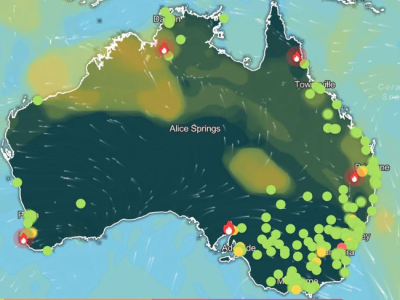
Thousands across Australia woke to an eerie sight as vast clouds of red and yellow dust swept across multiple states, triggering warnings and disrupting daily life.
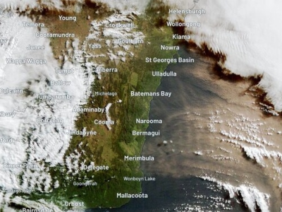
A weather warning was issued for Sydney on 27 May after thick plumes of dust engulfed the city, with strong westerly winds dragging the debris from inland regions.
Sydney Harbour was barely visible beneath the haze, as the Bureau of Meteorology flagged hazardous conditions and urged caution.
Air Quality NSW reported ‘hazardous’ air quality in Parramatta North, while areas like Albion Park South, Kembla Grange, Wollongong and Bargo were rated ‘extremely poor’, with particle levels (PM10) spiking beyond 600.
Western Sydney suburbs including Penrith, Oakdale, Richmond, Rouse Hill, Prospect and Macquarie Park recorded ‘very poor’ air quality.
Particles detected in the air included dust and sea salt, but also combustion-related pollutants from fires, vehicles and industry.
‘These particles can pass into the lungs. Short-term impacts include difficulty in breathing and worsening of asthma or chronic bronchitis symptoms. They can also cause irritation of eyes, nose and throat,’ Air Quality NSW warned.
Residents were advised to keep windows shut, limit time outdoors, and seek refuge in airconditioned buildings if their homes became uncomfortable.
‘If you feel that the air in your home is uncomfortable, consider going to a place with cleaner air (such as an airconditioned building like a library or shopping centre) if it is safe to do so,’ the website stated.
The situation added to the hardship already felt across New South Wales, where many were still cleaning up after devastating floods the week before.
Blistering winds compounded the state’s woes, battering the Northern Tablelands, Mid North Coast and other regions still recovering from extreme weather.
‘We do have damaging wind warnings current for much of the ranges of NSW,’ said senior meteorologist Dean Narramore.
‘That includes the Northern Tablelands and the higher elevated parts of the Mid North Coast and Northern Hunter and also damaging winds…through the Blue Mountains into the Illawarra escarpment, down through the elevated parts of the South Coast of NSW and for the Snowy Mountains.’
Wind gusts through Barrington Tops and the Snowy Mountains reached speeds over 90km/h, while Sydney itself recorded gusts up to 45km/h.
Visibility dropped sharply as dust blanketed the city in orange and yellow hues.
The winds were expected to settle by evening of 27 May, though forecasters predicted they would return by 29 May.
Rain also drenched some pockets of NSW, with 20mm–40mm recorded in parts of the Hunter and northern regions during 27 May.
‘That will clear off,’ Mr Narramore said.
South Australia bore the brunt of the dust storm on 26 May, with towns engulfed by red clouds and visibility reduced to as little as 300 metres.
Wind speeds surged to 107km/h in Maitland, while Cape Border and Cummings recorded over 100km/h overnight.
Mildura in western Victoria also experienced the full force of the dust storm, with roads disappearing under thick clouds as cars pulled over to wait it out.
Power outages hit hard in South Australia, with more than 3000 homes left without electricity on 27 May.
Source: Tiktok/aljazeeraenglish
In Adelaide Hills, 55mm of rain was recorded on Maidment Rd, with 30mm–50mm in the Mount Lofty Ranges offering some relief amid the chaos.
The Marcellin Campus at Sacred Heart College closed its doors due to downed power lines creating a ‘significant safety risk’.
‘Powerlines are down on Cudmore St which poses a significant safety risk,’ a school statement said.
‘Accordingly, Marcellin Campus is closed today until further notice.’
A severe weather warning remained in place for the Flinders Ranges, around 200km north of Adelaide, where wind gusts of up to 90km/h were recorded.
Despite 26 May’s s violent conditions, Mr Narramore said South Australia would see calmer weather by 27 May, with scattered showers along the southern coast.
‘Most of that weather will clear out by the time we get to this afternoon and this evening as high pressure moves in,’ he said.
Source: Tiktok/@7newsaustralia
Meanwhile, other capital cities were also dealing with wild weather.
Brisbane had a top of 29C, cloudy skies, winds up to 45km/h and a slight chance of showers.
Sydney peaked at 19C with strong winds and partial cloud cover.
Melbourne endured a high chance of afternoon showers, gusty winds and a top of 16C.
Adelaide saw a partly cloudy day with a medium chance of showers and a maximum of 18C.
Hobart was hit by westerly winds, showers and a top of 15C.
Perth remained the standout with sunny skies, north-easterly winds and a comfortable 21C.
Canberra faced cold and wet conditions with showers likely and a top of 12C.
Darwin stayed hot with a top of 31C, partly cloudy skies and showers expected later in the day.
For those wanting a closer look at the chaos unleashed across the country, footage captured the intensity of the wild weather as it unfolded.
Watch the full video and see how communities were impacted.
Source: Youtube/ABC News (Australia)

With such extreme weather sweeping across the country, how prepared do you feel for the next major climate event? Let us know your thoughts in the comments.
What began as a regional disturbance rapidly intensified, leaving residents reeling amid a haze of dust, power outages and dangerous winds.
What followed were stark warnings, hazardous conditions and ongoing recovery efforts as the nation faced yet another climate challenge.
Thousands across Australia woke to an eerie sight as vast clouds of red and yellow dust swept across multiple states, triggering warnings and disrupting daily life.
A weather warning was issued for Sydney on 27 May after thick plumes of dust engulfed the city, with strong westerly winds dragging the debris from inland regions.
Sydney Harbour was barely visible beneath the haze, as the Bureau of Meteorology flagged hazardous conditions and urged caution.
Air Quality NSW reported ‘hazardous’ air quality in Parramatta North, while areas like Albion Park South, Kembla Grange, Wollongong and Bargo were rated ‘extremely poor’, with particle levels (PM10) spiking beyond 600.
Western Sydney suburbs including Penrith, Oakdale, Richmond, Rouse Hill, Prospect and Macquarie Park recorded ‘very poor’ air quality.
Particles detected in the air included dust and sea salt, but also combustion-related pollutants from fires, vehicles and industry.
‘These particles can pass into the lungs. Short-term impacts include difficulty in breathing and worsening of asthma or chronic bronchitis symptoms. They can also cause irritation of eyes, nose and throat,’ Air Quality NSW warned.
Residents were advised to keep windows shut, limit time outdoors, and seek refuge in airconditioned buildings if their homes became uncomfortable.
‘If you feel that the air in your home is uncomfortable, consider going to a place with cleaner air (such as an airconditioned building like a library or shopping centre) if it is safe to do so,’ the website stated.
The situation added to the hardship already felt across New South Wales, where many were still cleaning up after devastating floods the week before.
Blistering winds compounded the state’s woes, battering the Northern Tablelands, Mid North Coast and other regions still recovering from extreme weather.
‘We do have damaging wind warnings current for much of the ranges of NSW,’ said senior meteorologist Dean Narramore.
‘That includes the Northern Tablelands and the higher elevated parts of the Mid North Coast and Northern Hunter and also damaging winds…through the Blue Mountains into the Illawarra escarpment, down through the elevated parts of the South Coast of NSW and for the Snowy Mountains.’
Wind gusts through Barrington Tops and the Snowy Mountains reached speeds over 90km/h, while Sydney itself recorded gusts up to 45km/h.
Visibility dropped sharply as dust blanketed the city in orange and yellow hues.
The winds were expected to settle by evening of 27 May, though forecasters predicted they would return by 29 May.
Rain also drenched some pockets of NSW, with 20mm–40mm recorded in parts of the Hunter and northern regions during 27 May.
‘That will clear off,’ Mr Narramore said.
South Australia bore the brunt of the dust storm on 26 May, with towns engulfed by red clouds and visibility reduced to as little as 300 metres.
Wind speeds surged to 107km/h in Maitland, while Cape Border and Cummings recorded over 100km/h overnight.
Mildura in western Victoria also experienced the full force of the dust storm, with roads disappearing under thick clouds as cars pulled over to wait it out.
Power outages hit hard in South Australia, with more than 3000 homes left without electricity on 27 May.
Source: Tiktok/aljazeeraenglish
In Adelaide Hills, 55mm of rain was recorded on Maidment Rd, with 30mm–50mm in the Mount Lofty Ranges offering some relief amid the chaos.
The Marcellin Campus at Sacred Heart College closed its doors due to downed power lines creating a ‘significant safety risk’.
‘Powerlines are down on Cudmore St which poses a significant safety risk,’ a school statement said.
‘Accordingly, Marcellin Campus is closed today until further notice.’
A severe weather warning remained in place for the Flinders Ranges, around 200km north of Adelaide, where wind gusts of up to 90km/h were recorded.
Despite 26 May’s s violent conditions, Mr Narramore said South Australia would see calmer weather by 27 May, with scattered showers along the southern coast.
‘Most of that weather will clear out by the time we get to this afternoon and this evening as high pressure moves in,’ he said.
Source: Tiktok/@7newsaustralia
Meanwhile, other capital cities were also dealing with wild weather.
Brisbane had a top of 29C, cloudy skies, winds up to 45km/h and a slight chance of showers.
Sydney peaked at 19C with strong winds and partial cloud cover.
Melbourne endured a high chance of afternoon showers, gusty winds and a top of 16C.
Adelaide saw a partly cloudy day with a medium chance of showers and a maximum of 18C.
Hobart was hit by westerly winds, showers and a top of 15C.
Perth remained the standout with sunny skies, north-easterly winds and a comfortable 21C.
Canberra faced cold and wet conditions with showers likely and a top of 12C.
Darwin stayed hot with a top of 31C, partly cloudy skies and showers expected later in the day.
For those wanting a closer look at the chaos unleashed across the country, footage captured the intensity of the wild weather as it unfolded.
Watch the full video and see how communities were impacted.
Source: Youtube/ABC News (Australia)
Key Takeaways
- Dust storms swept across several states, turning skies red and yellow and causing hazardous air quality in Sydney and surrounding regions.
- Strong winds reaching over 90km/h hit areas in NSW and South Australia, prompting severe weather warnings and reducing visibility.
- Thousands of homes lost power in South Australia, with schools like Marcellin Campus forced to close due to downed powerlines.
- Weather varied across capital cities, with Brisbane, Perth and Darwin experiencing warm conditions while others faced rain and wind.
With such extreme weather sweeping across the country, how prepared do you feel for the next major climate event? Let us know your thoughts in the comments.


